Wednesday, July 5, 2023

Trip #18, days 3-4. Magnetic Island and back to Townsville

 Day 3. Had a lazy morning to relax and tidy up aboard, among the larger cruising yachts at anchor.


Here are photos of Teria's latest daytime cruising interior layout 

Cabin layout

Starboard forepeak - storage
Port forepeak - storage

Starboard main cabin - table space


Port Main cabin - Nav nook

In the above cabin photos note: New attachment points for curtains were added and worked well. Wooden blocks were glued to the coachroof insides with silastic type sealant (incase they need to be moved later) and stainless steel screws were used as the hook points for the expanding curtain wires onto with own end hooks. (Re-used the forepeaks curtains and wires). For the saloon windows "curtains"  only the top expanding curtain wires were fitted  (from Bunnings hardware - curtain wires kit).  These make good tea-towels or wet clothes lines. No need for proper curtains or the lower wires just yet.

While anchored, the sails were reefed down.  (#2 jib hanked on and the main has 1 reefing point) This saves going on deck later in fresh wind open waters , a safer/easier option.

Headed out and encountered a fresh 15-20 knot wind with 1m seas, which made it difficult to use the short route to Townsville (on the eastern coast of Magnetic Island) which would be a painfully slow windward bash into steep seas. Instead sailed westwards with sea and wind on the quarter along the North coast of the Island. At first boatspeed was about 4-5 knots, then the wind kept increasing in strength so after an hour boat speed was 6-7 knots on the GPS! (which is about the quickest Teria has ever travelled at sea, tail current perhaps?). 

After rounding Liver point into Rollingstone Bay area (west end of Island), the wind was much reduced by the hills. At first light winds bent around the point, then motoring began in the Islands'  wind-shadow area, and continued on to west point where a fresh breeze on the nose resumed. Some hefty big cabin-cruisers were able to bash straight into the fresh 20 knoter back to Townsville, but i anchored off West Point beach for an overnight stay. Called Coastguard on VHF radio to extend the trip-sheet return by 24 hours. Unfurled and lowered the #2 jib to the deck (less windage , no chance of unfurling accidentally) In the past West point has proved to be a good lunch-break and swim anchorage, so i thought it might be ok for overnight anchoring as well.. 

West point Magnetic Island


Make shift sun shade (and drying out shirt)


Nice sunset from West point - looking towards Bay rock


Echo sounder/ fish finder display

The echo-sounder worked well,  (aka "fish finder"). Top left screen shows Depth (m), water temperature, battery voltage and local time. The corrugated bottom profile is caused by the boat pitching in small waves, fish blip in water colum and "noise" at top (the transducer is transom mounted, it's only 1-2 cm underwater at rest, it may pitch out momentarily above surface at times? but the depth readout always remains steady). Figured 2.8m would be a good depth with the forecast low tide.

About 8pm,  it was apparent that the anchorage didn't have enough protection from small waves coming in from several directions at the same time. Waves bent around the island here, forming a confused sea. Perhaps changing tides also played a part, hard to see much at night. The result was that Teria had a very uncomfortable confused motion so I couldnt get any sleep. 

So around 10pm, decided to motor 7 miles upwind to the  "Duckpond". However, there was an unusual late night fresh breeze (15-20 knots?) but decided to have a go anyway. At first Teria only crept ahead at low rev's at 2.5 knots to stop too much bow spray flying aft and to clear a wide shoal draft area (~2m deep).

 Headed into the wide but shallow "west channel" between Magnetic Island and the mainland (Cape Palleranda). In these conditions at night, it was almost essential to have the GPS chartplotter, sounder and red lit compass. This was my first major attempt at night-navigation on Teria. It's next-level above day-time navigation.   Also it proved essential to have the ultra long shaft outboard powerfull enough 6hp outboard  in these conditions, so the prop remained submerged 99.9% during wild pitching (did cavitate it twice mid channel though) and it's power/high torque propellor could overcome the considerable windage drag on the hull/rig. Also the completely lowered jib was snug and helped reduce windage allot.  It seemed to be a pitch black night except for distant city lights. The cabin acted like a spray dodger if sitting on the cockpit floor, but it was zero-viz ahead protection, so had to sit up to have a good look ahead and get soaked every minute or so.

First headed over towards Cape Palleranda, (to avoid hitting middle reef and hopefully find smaller waves) The seas got a bit better over there so could increase to 3.5 knots GPS speed. The echo-sounder allowed minimum depths to be avoided, i found that water less than 3m deep caused the waves to get much more violent, so heading deeper whenever this happened reduced the motion.

Passed close to a fishing shoal where a couple of rugged fishermen in a tinny were still fishing in the uncomfortable conditions. As Rowes Bay was approached, the waves kept improving steadily, so speed could be increased to 4, then 4.5 knots. The seabreeze should have died off by this late hour, but unusually it just kept blowing fresh well into the early hours and from a direction with maximum fetch (distance, >20km) for seas to become rough for any small craft. Felt safe again, once "The Strand" (Townsville's tourist beachfront) was abeam.

Entered the Duckpond around midnight, crawled in at 1 knot because there was a confusing myriad shore lights (port/ships) mixing with nav lights and anchored vessell lights. Used a strong torch to see hulls, some had no lighting at all. Used the Casino building as a known landmark, it had a distintive green light on this approach (but can change to purple..) 

Finally the anchor ratted down, the anchor light went up and the 3 nav lights went off. Thankfull for flat waters again for a decent sleep. It always feels good to anchor in a reliable safe harbor after a challenging time out there but it was a good learning experience.

Day 4: 

The Sunrise was a welcome sight. Mornings in the duckpond are often spectacular and the vessels there are interesting. 

Duckpond sunrise - Port bulk loading facility

Castle Hill and cruising yachts

Catamarrans and Teria can use the uncrowded shallow area, Townsville port gantries behind Ross creek rockwall.


Duckpond - Ports cargo docks and bulk sugar sheds on right (also a cruise ship dock)

Deep sea cutter rig cruiser - "The Strand" behind

World cruising 60-70ft motor-sailing ketch rig

Converted mackeral boat - Magnetic Island behind

Cruising yachts - Duckponds breakwall (and "Maggy")

Casino (left) and breakwater marina (right) - A new hotel the "Ardo" under construction. 

Didn't delay and headed off for Ross River early (as it's usually calm conditions early mornings). Motored out and found the wind/waves were still from the SE but moderated to about 10 knots. Teria was ok going straight into it at 4 knots. Crossed the main channel of the port while it was quiet, passed the outer bulk loading berth and new rockwall extension with its channel dredge sediment unloading dock.
Port Extension - Google maps 2023

The port expansion is a A$1.64 billion, 30 year, project which will allow panamax-sized ships upto 300m long gain access in a few years time Townsville port expansion project. For now the dredges will operate in the channel until 2024. Dredging channel. This a good detailed overview with photos from 2019 just before they started https://www.ship-technology.com/projects/townsville-port-expansion-project/ The project should lower import container shipping costs (and hopefully retail prices) for North Queensland consumers too. Currently Townsville is the largest port in Australia for sugar, lead (Pb), zinc (Zn), copper (Cu) and fertiliser (Phosphate) exports and biggest container and automotive import port in northern Australia. 


Used the Garmin handheld GPS/chartplotter to go to the "lead lights line" for Ross River. This kept Teria well away from the new port rockwall to leeward (with wave reflection etc), and was good to practise by day, just incase it has to be done at night in future (perish the thought). Once on the lead (pronounced "leed") lights line, turned Teria hard right, then entered the river mouth with beam wind/seas which was an easier motion.

Being a Sunday, the river was busy with small fishing "tinnys",  Aluminium or fibreglass open runabouts from 3-5m length anchored everywhere. So anchored Teria in a new spot to de-rig the mast, the depth sounder made this an easy thing to do safely.

Derigging Teria's mast 


Ross River mouth and channel looking seaward - ominous clouds


Castle Hill 

The Port Bridge - 6m clearance, TSers' lower masts! 

Fishing at Ross River mouth on sandbar (at my usual de-rig/rig spot)

Secret beach. Cats are great for tidal beaching/maintenance. 


Each pontoon has 4 ramp lanes, all are wheel chair accessible, seperate floating dock to left also with wheelchair access gangway.


Ramp signage - Coast guard log-in reminder and dredging operations warning.

Trip #18 Teria - June2023. Cleveland Bay and Magnetic Island


Dometic Cool-ice 33L Esky

This was the first test-voyage for the new Esky (or "ice-box"). It performed very well too, staying cold the entire 4 days and 3 nights trip. At home the ice bottles still had about 20% ice remaining, ( Didn't drain the cold water out). This long ice time meant that no dry backup food supplies were touched (only the "breakfast box" powdered milk, coffe, tea and cereals.) The Esky kept pre-cooked meal boxes, fresh fruit, butter, luncheon meat, chocolate etc and  (1litre) of milk cold for the entire trip. The esky had about twice the cold-time endurance of my old blue "ice coolers" (which are now relegated to shorter land trips)

"Ice Box" Esky - Dometic Cool Ice 33L


The esky has 35mm of good foam bonded to tough rotomoulded HDPE plastic outer and inner layers. The airtight lid has a neoprene gasket and precise hinges. There is a drain plug but it wasn't needed as ice was inside 6.5 litres of plastic bottles (from the home freezer). It's strong - can kneel ontop of it to get into the storage area and even sit on it in the cabin, an extra seat. It's also a small bench top.

It is a perfect size and for Teria's short handed cruising trips of 3-6 days duration. (It might be a tad too tall for I563's that want to fully use their foward bunk boards and sleep more crew upfront though)

It can be bought at most camping stores eg Snowys, Sydney - Dometic Cool ice 33L. (Lots more details and specifications)

It's small enough to be carried/maneovered by one person fully loaded up as well. Can load up ice and food in the kitchen, get it through the boats companionway into the cabin. It's small and light enough to slide backwards to free up some legroom in the "head" (chemical toilet in forepeak). It's large enough to hold 4 days of cold food for one person.


Saturday, July 1, 2023

Trip #18 Cleveland Bay and Magnetic Island (Days 1 & 2)

 The first trip of 2023 at long last. 8th to 11th June. It was also a "shakedown cruise" as both Teria and skipper have been ashore far to long and there were a few new boat additions to sea-trail as well.


Day1: After reading all the signage (crocodile habitat, port extension works, marine park zones etc) launched Teria at Ross River boating park ramp ok and motored over a quiet spot upstream to anchor overnight. I like the flat waters on the river, very few other boats and a just a few seabirds on the river bank. 

Launching depth for trailer and boat

Launching ramp and pontoon


Mast down portable anchor light rigged

 Tried the Aust volunteer Coast Guard's "trip log" mobile app for the first time. At Coast Guard they can then see all the planned trip details on their computer. 

It was the first sea test of the Garmin fishfinder and handheld GPS chartplotter, both worked well. Also the first sea test of the Huntingford Helm Impeder, it kept the boat on course while on the foredeck while anchoring. Also first trip out for the Dometic 33L cool-ice esky with 4-day ice holding.

Fish finder/depth sounder (and esky's) first trip out

Handheld GPS chartplotter with bracket mount, first trip out. The blue area indicates a shallow tidal zone.

The electronic chart on my GPS, has all the navigation beacon lights and navigational hazards on it. This is great if selecting a new anchorage area, the GPS chart shows where any rocks, reefs, wrecks or undersea cables or pipelines are located, so they can be avoided. The zoom function can be used to get a good look.  leave my GPS bracket unsecured while moving, as the GPS is designed to be handheld to operate and see the small chart screen. After use i stow the GPS on its bracket.   It's portable and floats, so can be used on other small craft like dinghy's.

Day 2: The millpond waters, mossie net and coil made for a sandfly free good sleep onboard.  

A good mosquito net over the hatch is needed in tropical mangrove creeks

Another first use item for me. Activated another Coast Guard mobile phone App called "Safe trx". It plots your GPS position every minute or so on "Google maps", and coast guard base can follow your exact path/position in real time. It's good for when on the move between destinations, so long as you have mobile phone signal. 

Glassy waters at Sunrise on Ross River 


Quiet part of Ross river, Mt Stuart (VHF repeater on top)

Motored out past the cabin-cruiser moorings and past the port bridge to re-anchor, slowly raise the mast and setup sails etc. 

Townsville Port's extension was well underway. The rockwall is far longer and the new wall is also a bit higher than the original ones. It forms a huge sea-pond which is being backfilled by dredge sediment from the main access channel expansion (wider and deeper, for bigger ships).

Calm morning for motoring, Townsville and Castle Hill astern

It was flat calm on Cleveland Bay at mid morning. After an hours motoring it was unusually calm still, so changed plan a bit and set course for Cape Cleveland lighthouse. It's normally in a difficult upwind position from Townsville, but conditions were perfect to reach it around noon time. Teria was cruising along at 5.1 knots, over a flat sea-grass seabed just 15 - 25 feet below. Spotted the water swirl from either a sea-turtle or dugong which feed on the seagrass meadow below.

Also wore my new PLB in a waist-bag at all times while the boat is moving offshore. Read of a life-saving rescue of a solo sailor in a very remote region, only the PLB alerted and guided SAR crews to him in the middle of the sea. He would've been lost and drowned without it. Hope it's never needed.

The seabreeze began to come in when 20 minutes from the Cleveland lighthouse, however this was ok as the sizeable hills of Cape Cleveland kept the waves down in their lee. 

Anchored for lunch and a rest near the high tide.  The depth sounder and GPS chart helped find the best anchoring location and safe depth. (The tide was falling, so these two navigation aids prevent getting stranded by the tide in unfamiliar waters)

Cape Cleveland hills and lunch anchorage

Cape Cleveland historic lighthouse

Hauled the kayak onboard and stowed on foredeck (always do for rougher sailing legs) Set full sail and course for Magnetic Island, now about 10 miles downwind. The wind was about 10-15 knots SE so made good speed.  Passed an empty bulk carrier ship, floating high on it's marks, it was one of two waiting to enter port. The sounder saying it was about 16m deep, (the deepest water on the whole trip). It also indicated that the seafloor is very flat overall around Cleveland bay.


Heading westward on a nice broad reach


Magnetic Island on the port bow


The bimini shades the cockpit while keeping an eye on the anchored ship

Bulk carrier at anchor

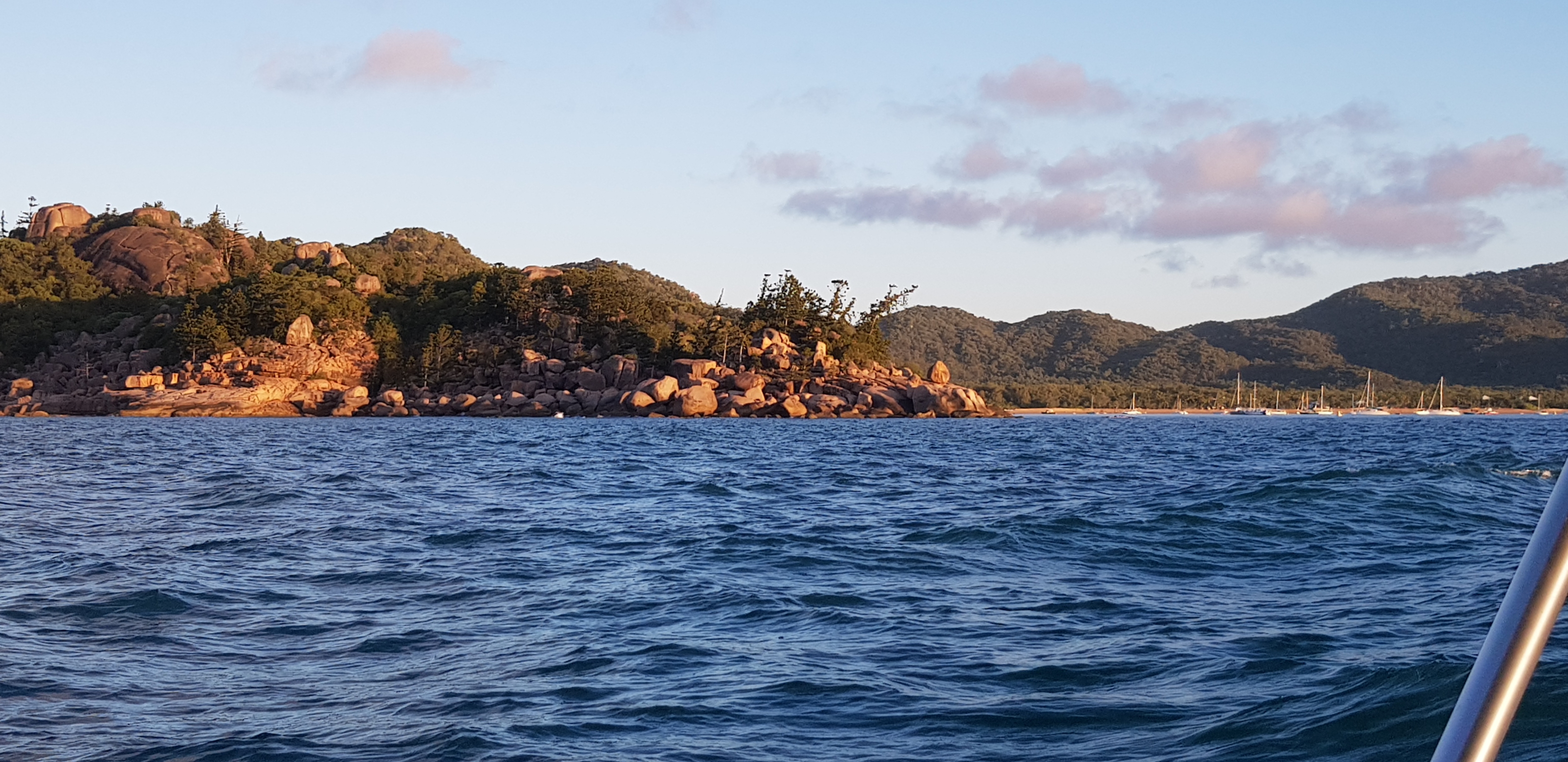
The sun was low in the west and lit up the granite hills of Magnetic Island brilliantly. About 20 or more yachts/vessels were anchored in Horseshoe bay, so carefully sailed in past them and found an open area among the shoal draft vessels (Catamarans and cabin-cruisers) closer to shore. Logged off the "Safe Trx" app after anchoring safely. 

The hills of Magnetic Island on approach from South to Horseshoe Bay
A fleet of cruising yachts, cabin cruisers and a few trawlers anchored at Horseshoe bay.

A golden-red sunset backlit the fleet with their masthead anchor lights on for the night (my anchor light is setup in the rigging, relatively low at about 6ft above deck, next to the mast - but reckon it's a good spot for any yacht's dinghy crew to see in the dark) Moon rise was around 11pm, so there was a good night-sky of stars. 

The "Evening Star" - Planet Venus is the first celestial body to show at dusk

Horseshoe Bay anchorage, masthead lights

The cockpit galley - Trangia, LED lantern and sink bowl.

Most of my dinner food for the trip was pre-cooked, packed into plastic containers and stowed in the esky. The Trangia 27 spirit cooker re-heated dinner  and still had plenty of fuel in it's burner to boil a couple of kettles of hot water for the thermos and a hot milo. Simple but effective. A small plastic bin with a recycled bread bag was good for any rubbish generated aboard.


Wednesday, June 21, 2023

27 Mhz marine radios

 27 Mhz marine radios are short-range entry-level units. 

They are the cheapest ship stations, run on a 12v battery and don't require an operators licence (certificate). They are good for inshore boating, on sheltered waters like tidal estuaries-rivers or protected bays. The maximum range is about 5 nautical miles (10km) line of sight only. Rescue bases sometimes monitor them, but it's best to check with your local base if they do this safety service or not

Radio traffic is generally more localised, among recreational fishermen, trailer sailers and other small craft, perhaps with a marine rescue base on listening watch by day.  


New units are around A$200 (plus aerial), seen some secondhand ones for about A$40.

They have 2 calling channels and 8 working chanels to talk on. A Channel sticker can be placed beside the radio station which indicates which chanels are best for different groups. 


Calling Channels 88 and 86 are for initial calls or distress calls. Listening watch is on these.

The working channels. Ch 96 and 94 are for talking to other recreational boats. Ch 94, 90, 91 for talking with Coast Guard or VMR bases. Safety/weather messages are  on ch 98. The other 3 channels are for talking with commercial vessels (if they have a 27Mhz).

There are no repeater channels, so range can't be extended as for VHF radios. 

But they might be ideal for some inshore boaties who would like to stay easy and simple. General operating procedures and calls are otherwise similar to other types of marine radio like VHF.

Most State Authorities encourage study of the VHF radio handbook for calling procedures information. 27Mhz chanels are simplex (single frequency) the handset has a "Push to talk" (PTT) button on it which must be released after "over", so the other radio can respond.

The main thing is to initiate calls on a calling channel, say Ch88. Call another boats/VMR/CG bases name 3x, then "this is", your call sign 3x, your contact message and "over". Await reply, always say "over" to allow the other radio to transmit next. Then go to an agreed working channel to continue conversations. End communications with "OUT". Then go on "listening watch" on Ch 88. Keep the radio switched on while active on the water. 

The VHF 12v battery procedures/servicing apply. 27Mhz have their own aerial type as well which must also be well fitted/high as practical.

It does seem like VHF's (and mobile phones/apps) are taking over from the old 27 Mhz technology. If buying a new radio my choice would be VHF over 27Mhz. (but it's needed for semi-offshore cruising) It's also what most marine rescues recommend or encourage. Still the humble 27 mhz might still have appeal and do a good job for some who don't wish or plan on going out too far.

This is a good web page about getting into all 3 types marine radio's (27mhz, VHF and HF) what each type can or can't do and the licencing requirements.

marine radio safety -South Australian Government


Tuesday, June 20, 2023

Long Range radio - HF radio

A LROCP (Long Range Radio operators Certificate of Proficiency) is required to operate an HF long range radio in Australia.    It's an advanced level radio certification, usually for profesional seafarers, blue water or offshore yachtmen or volunteer marine rescue crew members. The licence was formerly known as a MROCP (Marine radio Operators Certificate of Proficiency).

Courses are usually available with with marine training providers or at local marine rescue bases.  The LROCP in my area costs around A$190 or so in 2023 ($60 for manual)  The course also covers and expands on the SROCP content  (short range radios, VHF etc)


HF radios

These are long range transceivers. For serious blue water voyaging or offshore use beyond VHF ranges.
They bounce radio waves off the ionosphere, so the signals can go far beyond the horizon and around the earth. A knowlege of the channels frequency capabilities is required under different atmospheric condiditions. Different frequency channels are used to optimise the signal clarity/ range to operate in etc.

Marine HF radio monitoring by shore stations in Australia has recently switched from States/Terittory jurisdiction to  AMSA a federal body. AMSA HF Radiotelephone monitoring (Dec 2021). This  interesting story in the lead-up to the changes Australia floats plan to phase out HF radio monitoring by 2022  (Oct 2019).  It seems that HF radiotelephony is rarely used for distress calls far at sea nowdays, due to the advancement of GPS EPIRB's and similar technology taking over this role (including HF DSC units)  But AMSA still monitors HF for distress calls and many other services such as BOM weather information and warnings etc are still broadcast to mariners who are well beyond VHF range.

HF marine radios arent cheap, they cost several thousand dollars (eg $2,500 - >$6,000 depending on capability functions and brand)


Wednesday, May 31, 2023

Marine VHF radios

 This is the follow on from the PLB and EPIRB post (with or without GPS). A caveat, this information is for Australian waters and local area. It's always best to check with your local authorities first as regulations/channel frequencies differ a bit interstate or overseas (eg USA).

VHF is a good short range radio, more capable than a 27Mhz unit. It has increased range, power and signal clarity. Range depends on the height of the transmitting and receiving antenna's, the higher the better. It ranges from 5 nautical miles to 60 nm. The low ranges are when the antenna is mounted to a small crafts deck and the long ranges are thanks to repeater towers on mountain tops. Medium ranges are when the antenna is located on a ships' masthead or shore bases' tower.

VHF's (or any type of marine radio) must never be operated on dry land. Also false distress messages are absolutely taboo and huge fines apply for this offence.


VHF radio, navigation and safety area on Teria

Chanel 16 is monitored 24/7 by marine authorities ashore and commercial shipping.  In Australia, a licence to operate a VHF radio is required. (Unlicenced boaters can make emergency calls only or  listen in.) There are 3 recreational boat talk channels ch 72, 73 and 77. 

VHF's have two power settings. 1 watt and 25 watts. low 1 watt power is used most of the time. If the first call can't get through, i then use the repeater channel still on low power.  High power is rarely  needed, perhaps only when at maximum range or when in a serious situation.

VHF courses for a Marine radio short range operators VHF certificate of proficiency (SROCP) can usually be done at most volunteer rescue bases or through  navigation training companies.


I just completed my SROCP exam with a local navigation training company in Townsville (The Navigation Center) in conjunction with online resources of the AMC (Australian Maritime College) in Tasmania.  All VHF radio exams in Australia are certified through this one authority. 

Most of my study was at home, using the $30 VHF radio book and AMC online non-assessable "self-test" multiple choice questions to see how much you could understand. Then it was back and forth between book, self-test and any online web pages i could find on the subject. This was a good method as there was no time limit or "crash course" forcing you through it. Just study as long as you like until fully prepared for the exam, this suited me better. All up it cost $155.

The course covers all the operating procedures in different priority situations. Distress, Urgency, Safety/weather notices or regular calling and working transmissions. Channels are "protected" or reserved only for certain uses, messages are kept brief and to the point, mostly about trip plan/changes or difficult situations requiring assistance. The aim is to transmit on your designated channels only, short as possible, so marine radio traffic doesn't become congested.

My radio is an old GME GX548 Electrophone.   It has a power selector, squelch knob, on/off volume knob, channel buttons.  "AUS" selection button for Australian channels which MUST be on to get Australian/International channels (the other option is USA channels, which are different). There is also a button to flip between Ch 16 and a channel of your own choosing (usually the local repeater)

Teria's VHF antenna (or "whip") has been re-mounted on the aft rail's top 4 feet above the waterline (so the "whip" tip is 9ft high) to give a mile or two extra range. It was 2 ft lower before. It's a practical spot for a simple trailer sailer, because there's no problem with mast lowering or getting into a garage at home. It can also be easily removed and stowed for the road.

Yachts with fixed masts often mount their VHF whip permanently at the mast head, about 30-50 feet high. Big cargo or cruise ships whips are even higher.

My radio is an old model without DSC (digital select calling), so old-style radio procedures are used. 

DSC equiped radios can quickly transmit emergency information to other DSC VHF radios with the touch of a button. This feature increases chance of rescue significantly if the radio is connected to a GPS, as the coordinates are also transmitted instantly. An example is the Uniden UM455VHF at BCF.  They also have dual or triple watch scanning.

Uniden UM455VHF radio with DSC emergency button

I was looking through my old Qld boating guide 2012 and it listed all the LCS (limited coast stations) , all their watchkeeping channels (27mhz, VHF and HF) and phone numbers. In my more recent edition 2019 only VHF repeater chanels and phone numbers were listed in the table. The info booklets sure are changing with time. 

Each LCS usually only operates Ch 16 watchkeeping during daylight hours and each area can have different hours. After hours full Coast Stations continue the watch (eg Queensland State Governments, MSQ Maritime Services Qld). The LCS are usually volunteer marine rescue, yacht clubs (recreational vessels) and are "limited" in what they can do. The "Coast Stations" are for the Commercial and Government sectors eg. Big ships and their ports. They have advanced radio equipment and technology, including advanced VHF gear. My SROCP course covered a bit of this advanced technology as well.

Things like AIS (Automatic Identification Systems) transponders (both VHF or satellite connected) which send the position coordinates of a vessel out regularly, so that other AIS equiped ships can see each other plus vessel data on screens. AIS-B is available for yachts or motor-cruisers, it's the simpler cheaper version. (AIS-A is for big ships, expensive and has many more programable functions)


Floating Handheld VHF radios.

A good size in small craft, they can be carried on your person or stowed in or near the cockpit. Could be good if you have to abandon ship or if its overturned/sunk etc. 

A few cons are lower battery time, low transmitting power, lowest range, need to keep recharging if out for a few days and as for any VHF radio,  SROCP operator's licence is still required.

The Pro's. Cheap, small, lightweight, versatile, floats and mobile. It can be charged up by a car or boat's 12 volt system while on the move.


Uniden MHS050 VHF handheld


Uniden MHS155UV handheld VHF and UHF radio.

This VHF and UHF handheld is for the Amphibious crowd. VHF at sea or switch to UHF mode when ashore ( freshwater lakes/ rivers,  beaches, roads and highways). It also floats well. 


Electrical system

Preseason maintenance/upgrade on the 12volt electrical system was needed.

The switch panelwas homemade by a previous owner but lacked access behind it to actually work on it (no idea how he did it..)  However i like the general electrical box setup enough to just slightly modify it. 

After removing the louvred door, used a handsaw to cut the switches and  fuses free. 

3 gang homemade switch panel (Left to Right:  cabin, compass and nav lights)


Able to work on it at long last! 

Once accessible i wired the compass red night light to the vacant center switch and fuse. Red (small wire) connectors used, and a low amp glass fuse. 

Rehung the louvred door by moving the lower hinge up 5cm, so the 3 switch panel is clear and can be removed. 

Did look at proper 4 and 6 gange glass fuse/switch panels ($20-$35) and modern  4-6 gang breaker panels ($45-$60) they'd be an ideal situation, but would have to rebuild the entire front of the electrical box with new plywood to house them etc. Still use the "if it ain't broke don't change it" principle.

Battery isolation switch

This was vast overkill at 300A continuous draw but its nice and very solid. Siliconed a 12mm plywood back board to the bulkhead to attach it inside the electrical box, (and also relocated the solar panels charging regulator)


Narva Battery isolation main switch (and solar regulator)

Main switch wiring

The isolator switch is a "single battery" type with simple wiring.  Connected it to the brass bus bar with heavy wire and yellow connectors (large). It's very convenient and when "off" prevents any inadvertent battery draw down when away from boat, which should help extend battery lifespan. It cost $35 at Bunnings warehouse (they have a neat well priced 12V spare parts section) 

The battery charging cables are not affected as they are seperate circuits. So the house battery can still recharge when the battery isolator is "off". 

There are 3 ways to recharge the 102AH deep cycle battery. 1)  Smart charger  - 240v mains in regulated DC out (on a 24 hr timer at house, off for sleeping and sunny hours.)   2) onboard 37w Solar panel via regulator 3) 6hp outboard DC charger. The 3 cables simply run from each power source to positive and negative battery terminals.

Devices recharging station. 

Cleaned this up by simply using a double adapter 12v cig lighter plug with 2 USB charging ports, plugged into the old 12V cig lighter fitting.


Powertech 12v charging adaptor and LED lamp on recharge

In the picture is an Ironhorse rechargeable 200 /100 lumen LED lamp ($21 at Bunnings).  It's handy to light up the forepeak, quarter berths or cockpit areas. Get extra light where needed and backup if wired 12v fails. Very compact and stows easily. It also forestalls having to wire in extra cabin lights (eg forepeak could do with one). (The yellow 6v 3w LED hand torch was also at Bunnings for $10, it's far  brighter than my 1980's incandescent globe one which finally corroded inside and died) 

Here's some details of the cig lighter 12v DC charging adapter. It has 3amp (fast) and 2.4a (medium) USB A outlets, one 2.4amp USB C outlet, a digital voltmeter,  an on/off switch for each blue led lit cig socket and a 10Amp modern fuse underneath it. The output voltage from the usb's is stepped down to low levels for modern devices (eg 5v) It cost $36 at Jaycar electronics.

Powertech charging adapter specifications


.