Showing posts with label Cape Cleveland. Show all posts

Wednesday, December 4, 2024

June cruise 2024 (trip #20) - Day 3. Horseshoe Bay, Cape Cleveland and Townsville Duckpond

Horseshoe Bay sunrise and a Wharram cat


Anchored near shore, Horseshoe Bay.

Slipped away quietly under sail at 10am. The wind was weak, so hoisted the main at anchor, weighed anchor and ran downwind about along Horseshoe Bay beach (but outside the yellow shark control bouys) until clear of the anchorage area, then Gybed and headed seawards, in clear wind well away from the lee of the hills.

10/6/24, Day 3. It was a nice close haul on starboard tack into a 10 knot South west land breeze. Course was for Cape Cleveland, with a plan to gain southerly miles until the wind backed to the SE late morning as predicted, then sail for Townsville on port tack.

Clouds form out to sea over the great barrier reef

However nature doesn't always follow the "windy app" prediction. Instead the land breeze lasted hours longer, so just kept heading south. Which was easy because George was helming and the course was steady. 


Teria was only a mile from the Cape's lighthouse when the predicted wind shift happened, and it backed so it was right on the nose. Motored into it for 10 minutes and anchored in Redrock Bay for lunch. 

I had skipped brekfast and was ravenous, sandwiches and fruit never tasted so good.

Set off for Townsville at 2pm on a dead run with a 15 knot tail wind. The ST1000 was ok while the waves were slight for just the first mile or so. As fetch increased waves were formed, and George couldn't hold course, so I hand-steered for port at an easy 5 knots.

ST1000 steering Teria away from Cape Cleveland

I was getting a bit weary and didn't relish doing ramp haulout late afternoon. So called QF8 Townsville Coast Guard on the VHF and extended the trip plan by another 24 hours (They update the "Tripwatch" app and send a link to your mobile, the app shows you and others at home your current and past track on google maps). 

Now the time-pressure was off it was a nice sail and anchored in the Duckpond's flat waters for the night.


Saturday, July 1, 2023

Trip #18 Cleveland Bay and Magnetic Island (Days 1 & 2)

 The first trip of 2023 at long last. 8th to 11th June. It was also a "shakedown cruise" as both Teria and skipper have been ashore far to long and there were a few new boat additions to sea-trail as well.


Day1: After reading all the signage (crocodile habitat, port extension works, marine park zones etc) launched Teria at Ross River boating park ramp ok and motored over a quiet spot upstream to anchor overnight. I like the flat waters on the river, very few other boats and a just a few seabirds on the river bank. 

Launching depth for trailer and boat

Launching ramp and pontoon


Mast down portable anchor light rigged

 Tried the Aust volunteer Coast Guard's "trip log" mobile app for the first time. At Coast Guard they can then see all the planned trip details on their computer. 

It was the first sea test of the Garmin fishfinder and handheld GPS chartplotter, both worked well. Also the first sea test of the Huntingford Helm Impeder, it kept the boat on course while on the foredeck while anchoring. Also first trip out for the Dometic 33L cool-ice esky with 4-day ice holding.

Fish finder/depth sounder (and esky's) first trip out

Handheld GPS chartplotter with bracket mount, first trip out. The blue area indicates a shallow tidal zone.

The electronic chart on my GPS, has all the navigation beacon lights and navigational hazards on it. This is great if selecting a new anchorage area, the GPS chart shows where any rocks, reefs, wrecks or undersea cables or pipelines are located, so they can be avoided. The zoom function can be used to get a good look.  leave my GPS bracket unsecured while moving, as the GPS is designed to be handheld to operate and see the small chart screen. After use i stow the GPS on its bracket.   It's portable and floats, so can be used on other small craft like dinghy's.

Day 2: The millpond waters, mossie net and coil made for a sandfly free good sleep onboard.  

A good mosquito net over the hatch is needed in tropical mangrove creeks

Another first use item for me. Activated another Coast Guard mobile phone App called "Safe trx". It plots your GPS position every minute or so on "Google maps", and coast guard base can follow your exact path/position in real time. It's good for when on the move between destinations, so long as you have mobile phone signal. 

Glassy waters at Sunrise on Ross River 


Quiet part of Ross river, Mt Stuart (VHF repeater on top)

Motored out past the cabin-cruiser moorings and past the port bridge to re-anchor, slowly raise the mast and setup sails etc. 

Townsville Port's extension was well underway. The rockwall is far longer and the new wall is also a bit higher than the original ones. It forms a huge sea-pond which is being backfilled by dredge sediment from the main access channel expansion (wider and deeper, for bigger ships).

Calm morning for motoring, Townsville and Castle Hill astern

It was flat calm on Cleveland Bay at mid morning. After an hours motoring it was unusually calm still, so changed plan a bit and set course for Cape Cleveland lighthouse. It's normally in a difficult upwind position from Townsville, but conditions were perfect to reach it around noon time. Teria was cruising along at 5.1 knots, over a flat sea-grass seabed just 15 - 25 feet below. Spotted the water swirl from either a sea-turtle or dugong which feed on the seagrass meadow below.

Also wore my new PLB in a waist-bag at all times while the boat is moving offshore. Read of a life-saving rescue of a solo sailor in a very remote region, only the PLB alerted and guided SAR crews to him in the middle of the sea. He would've been lost and drowned without it. Hope it's never needed.

The seabreeze began to come in when 20 minutes from the Cleveland lighthouse, however this was ok as the sizeable hills of Cape Cleveland kept the waves down in their lee. 

Anchored for lunch and a rest near the high tide.  The depth sounder and GPS chart helped find the best anchoring location and safe depth. (The tide was falling, so these two navigation aids prevent getting stranded by the tide in unfamiliar waters)

Cape Cleveland hills and lunch anchorage

Cape Cleveland historic lighthouse

Hauled the kayak onboard and stowed on foredeck (always do for rougher sailing legs) Set full sail and course for Magnetic Island, now about 10 miles downwind. The wind was about 10-15 knots SE so made good speed.  Passed an empty bulk carrier ship, floating high on it's marks, it was one of two waiting to enter port. The sounder saying it was about 16m deep, (the deepest water on the whole trip). It also indicated that the seafloor is very flat overall around Cleveland bay.


Heading westward on a nice broad reach


Magnetic Island on the port bow


The bimini shades the cockpit while keeping an eye on the anchored ship

Bulk carrier at anchor

The sun was low in the west and lit up the granite hills of Magnetic Island brilliantly. About 20 or more yachts/vessels were anchored in Horseshoe bay, so carefully sailed in past them and found an open area among the shoal draft vessels (Catamarans and cabin-cruisers) closer to shore. Logged off the "Safe Trx" app after anchoring safely. 

The hills of Magnetic Island on approach from South to Horseshoe Bay
A fleet of cruising yachts, cabin cruisers and a few trawlers anchored at Horseshoe bay.

A golden-red sunset backlit the fleet with their masthead anchor lights on for the night (my anchor light is setup in the rigging, relatively low at about 6ft above deck, next to the mast - but reckon it's a good spot for any yacht's dinghy crew to see in the dark) Moon rise was around 11pm, so there was a good night-sky of stars. 

The "Evening Star" - Planet Venus is the first celestial body to show at dusk

Horseshoe Bay anchorage, masthead lights

The cockpit galley - Trangia, LED lantern and sink bowl.

Most of my dinner food for the trip was pre-cooked, packed into plastic containers and stowed in the esky. The Trangia 27 spirit cooker re-heated dinner  and still had plenty of fuel in it's burner to boil a couple of kettles of hot water for the thermos and a hot milo. Simple but effective. A small plastic bin with a recycled bread bag was good for any rubbish generated aboard.


Monday, April 24, 2017

Teria Cruise #14 - Leg 1 to Cape Cleveland

It's been over a year since "Teria" met the waves.  An unfavorable work schedule followed by the hottest wet season i can remember. (They didn't stop Fatty knees 8 sailing though)

We were also in the potential path of cyclone Debbie, forecast as a Category 4 (winds over 200 km/hr). To prepare for this everything was stripped off Terias decks, mast, rigging, shackled on fittings, the bimini, solar panel, anchor gear etc and the loose items stowed in safe places (In the cabin, house and under house). Finally fitted the shock-cord cockpit hatch tie downs and roped the main hatch down.

Debbie missed Townsville by 50 km (only a few hours of rain and 20-30 kn SW winds)  but hit Bowen, Whitsundays and Mackay, then ex-Debbie flooded the coast and inland of Queensland, Brisbane, Northern New South Wales and even crossed the Tasman to flood parts of New Zealand, like Bay of Plenty! caused allot of damage in it's wake, it was one of the most powerful ever and certainly had allot of stamina when over land)

Once the first signs of the tropical Autumn began (nights down to 24C, winds turning Easterly) it was time to prepare for sailing again. Everything had to be reattached to the deck, raised the mast and rigged up the sails, fitted the rudder, engine etc in the back yard to make sure it was all there. The engine was tank-tested, replaced a leaking fuel filter cover and made sure the cooling system was working.  These things were done in spare time a week to days ahead of the trip.

Day 1 - Night 1 - Ross River

Launched late in the day at Ross River ramp, soon the sun was setting so anchored across river from the boat park with mast down. It was propped up on the mast crutch aft, enough so the pop-top could be half raised. The river was smooth, sheltered from 20 knot winds and rough waters outside. Hardly any sandflies or mosquitoes mid stream and the mozzie coils kept them out without screening.

Hatch board table


Day 2. Ross River - Cape Cleveland...

The next morning was calm and serene.

Boiling the billy for breakfast in Ross River. Trangia stove.

Ross River. Removable anchor light on lowered mast.
Ross River, Boat Park.

Good conditions for the mast raising and rigging up outside the low bridge.

A strong out going spring tide helped speed Teria through the channel and onto Cleveland Bay. Motor sailing with a cool 2-3 knot SW land breeze, enabled Teria to lay Cape Cleveland light and do 6 knots over the ground in the nearly flat waters.

Navigation was now aided by my old Garmin GPS76s. It's around 2006 era and still working well. I used it for mineral exploration work in Australia and Vietnam years ago but it was stored in Thailand until recently. It started up no problems and the accessories were still there, 12v recharger cable and adjustable bean-bag dashboard mount.

It's map was very basic but enough to make a waypoint near the destination, get info like ETA and speed made good, time to destination and also a fluxgate compass with pointer arrow.

GPS navigation

GPS with course line page on chart.
 The trip over took around 2 hours, about hull speed all the way. The conditions ideal, Cape Cleveland is rarely visited by Townsville based yachts, as normally it would have been way up to windward in the usual NE to E prevailing trade winds.

Motor sailing across a flat sea towards the Cape.

On the way a large brown creature surfaced and dived - a Dugong, or sea-cow, a vegetarian sea mamal, probably about 2m long, they feed on the sea grass meadows below. The waters across here are very shallow generally less than 10 meters..


Cape Cleveland ahead

Anchored in Red Rock Bay. It's shallow sand bottom and sheltered by headlands.

The Cape Cleveland light-house is a historical one built in 1879. It's now automated and solar powered and not open to the general public. It can be visited through tours run by Sealink in Townsville.  The barge was ashore and a tour helicopter flew in, landed and took off.

Cape Cleveland light house

The mountains along the Cape, the coast is very shallow and tidal.

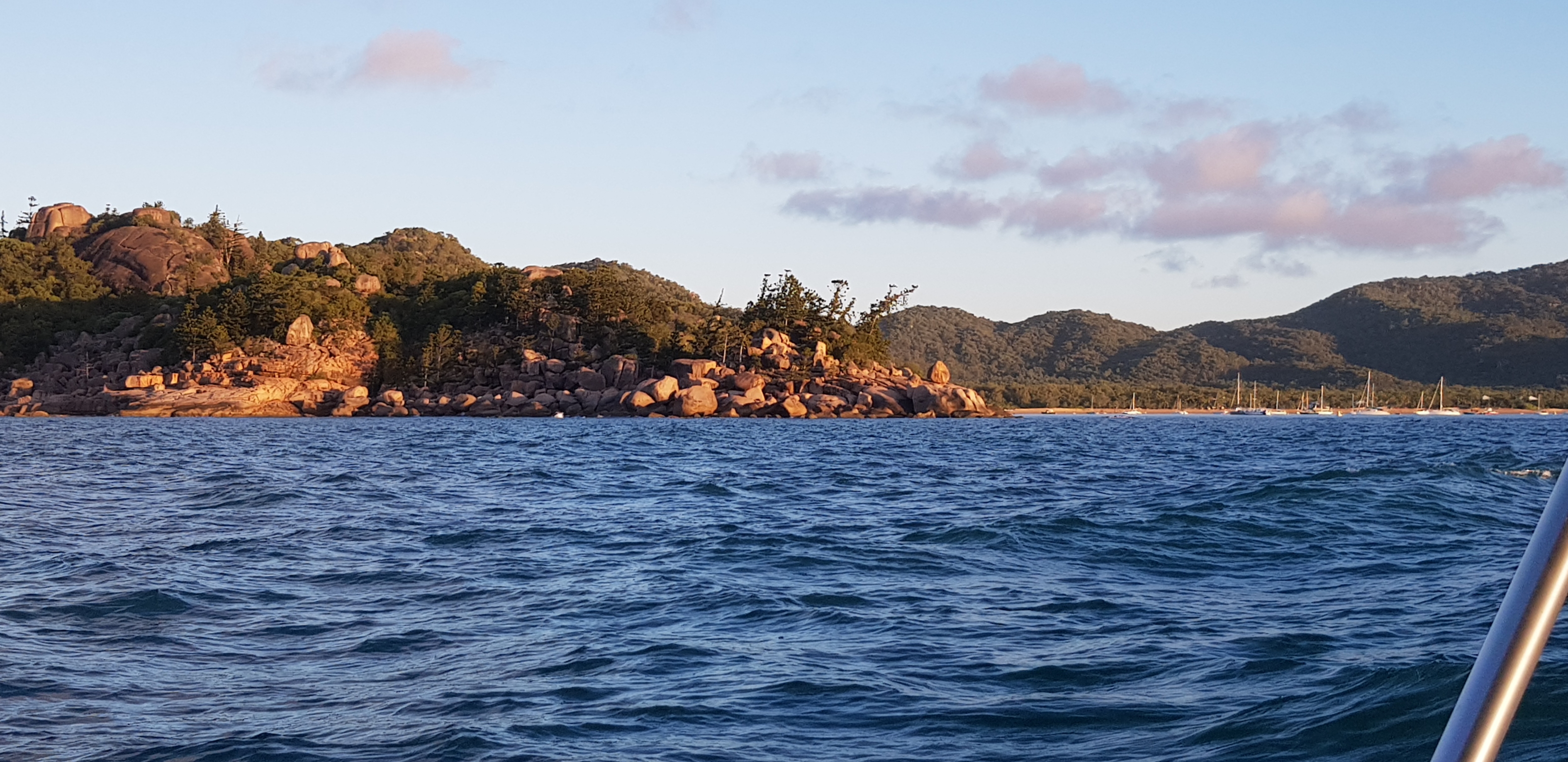
After lunch the sea-breeze picked up, so hoisted sail and raised anchor and bore away.  Now in a good windward position Teria sailed at around 5 knots broad reaching to a leeward Magnetic Island. The seas rose to over 1 meter, trimmed the centerboard back to help ease the weather helm.

Two large ships were anchored well off shore, both were floating high, waiting.  Teria passed astern of Larus a few miles off Magnetic Island.

Bulk carrier Larus