Showing posts with label trip log. Show all posts

Saturday, July 1, 2023

Trip #18 Cleveland Bay and Magnetic Island (Days 1 & 2)

 The first trip of 2023 at long last. 8th to 11th June. It was also a "shakedown cruise" as both Teria and skipper have been ashore far to long and there were a few new boat additions to sea-trail as well.


Day1: After reading all the signage (crocodile habitat, port extension works, marine park zones etc) launched Teria at Ross River boating park ramp ok and motored over a quiet spot upstream to anchor overnight. I like the flat waters on the river, very few other boats and a just a few seabirds on the river bank. 

Launching depth for trailer and boat

Launching ramp and pontoon


Mast down portable anchor light rigged

 Tried the Aust volunteer Coast Guard's "trip log" mobile app for the first time. At Coast Guard they can then see all the planned trip details on their computer. 

It was the first sea test of the Garmin fishfinder and handheld GPS chartplotter, both worked well. Also the first sea test of the Huntingford Helm Impeder, it kept the boat on course while on the foredeck while anchoring. Also first trip out for the Dometic 33L cool-ice esky with 4-day ice holding.

Fish finder/depth sounder (and esky's) first trip out

Handheld GPS chartplotter with bracket mount, first trip out. The blue area indicates a shallow tidal zone.

The electronic chart on my GPS, has all the navigation beacon lights and navigational hazards on it. This is great if selecting a new anchorage area, the GPS chart shows where any rocks, reefs, wrecks or undersea cables or pipelines are located, so they can be avoided. The zoom function can be used to get a good look.  leave my GPS bracket unsecured while moving, as the GPS is designed to be handheld to operate and see the small chart screen. After use i stow the GPS on its bracket.   It's portable and floats, so can be used on other small craft like dinghy's.

Day 2: The millpond waters, mossie net and coil made for a sandfly free good sleep onboard.  

A good mosquito net over the hatch is needed in tropical mangrove creeks

Another first use item for me. Activated another Coast Guard mobile phone App called "Safe trx". It plots your GPS position every minute or so on "Google maps", and coast guard base can follow your exact path/position in real time. It's good for when on the move between destinations, so long as you have mobile phone signal. 

Glassy waters at Sunrise on Ross River 


Quiet part of Ross river, Mt Stuart (VHF repeater on top)

Motored out past the cabin-cruiser moorings and past the port bridge to re-anchor, slowly raise the mast and setup sails etc. 

Townsville Port's extension was well underway. The rockwall is far longer and the new wall is also a bit higher than the original ones. It forms a huge sea-pond which is being backfilled by dredge sediment from the main access channel expansion (wider and deeper, for bigger ships).

Calm morning for motoring, Townsville and Castle Hill astern

It was flat calm on Cleveland Bay at mid morning. After an hours motoring it was unusually calm still, so changed plan a bit and set course for Cape Cleveland lighthouse. It's normally in a difficult upwind position from Townsville, but conditions were perfect to reach it around noon time. Teria was cruising along at 5.1 knots, over a flat sea-grass seabed just 15 - 25 feet below. Spotted the water swirl from either a sea-turtle or dugong which feed on the seagrass meadow below.

Also wore my new PLB in a waist-bag at all times while the boat is moving offshore. Read of a life-saving rescue of a solo sailor in a very remote region, only the PLB alerted and guided SAR crews to him in the middle of the sea. He would've been lost and drowned without it. Hope it's never needed.

The seabreeze began to come in when 20 minutes from the Cleveland lighthouse, however this was ok as the sizeable hills of Cape Cleveland kept the waves down in their lee. 

Anchored for lunch and a rest near the high tide.  The depth sounder and GPS chart helped find the best anchoring location and safe depth. (The tide was falling, so these two navigation aids prevent getting stranded by the tide in unfamiliar waters)

Cape Cleveland hills and lunch anchorage

Cape Cleveland historic lighthouse

Hauled the kayak onboard and stowed on foredeck (always do for rougher sailing legs) Set full sail and course for Magnetic Island, now about 10 miles downwind. The wind was about 10-15 knots SE so made good speed.  Passed an empty bulk carrier ship, floating high on it's marks, it was one of two waiting to enter port. The sounder saying it was about 16m deep, (the deepest water on the whole trip). It also indicated that the seafloor is very flat overall around Cleveland bay.


Heading westward on a nice broad reach


Magnetic Island on the port bow


The bimini shades the cockpit while keeping an eye on the anchored ship

Bulk carrier at anchor

The sun was low in the west and lit up the granite hills of Magnetic Island brilliantly. About 20 or more yachts/vessels were anchored in Horseshoe bay, so carefully sailed in past them and found an open area among the shoal draft vessels (Catamarans and cabin-cruisers) closer to shore. Logged off the "Safe Trx" app after anchoring safely. 

The hills of Magnetic Island on approach from South to Horseshoe Bay
A fleet of cruising yachts, cabin cruisers and a few trawlers anchored at Horseshoe bay.

A golden-red sunset backlit the fleet with their masthead anchor lights on for the night (my anchor light is setup in the rigging, relatively low at about 6ft above deck, next to the mast - but reckon it's a good spot for any yacht's dinghy crew to see in the dark) Moon rise was around 11pm, so there was a good night-sky of stars. 

The "Evening Star" - Planet Venus is the first celestial body to show at dusk

Horseshoe Bay anchorage, masthead lights

The cockpit galley - Trangia, LED lantern and sink bowl.

Most of my dinner food for the trip was pre-cooked, packed into plastic containers and stowed in the esky. The Trangia 27 spirit cooker re-heated dinner  and still had plenty of fuel in it's burner to boil a couple of kettles of hot water for the thermos and a hot milo. Simple but effective. A small plastic bin with a recycled bread bag was good for any rubbish generated aboard.


Monday, December 28, 2020

Hinchinbrook Island trip - Southern channel to Dungeness, road trip home (Day 5)

 Mon 28 Sept 2020.

After a good sleep and morning coffee, departed Haycock Island about 8 am. The early morning conditions were nearly flat calm, so the southern channel proved to be easy motoring at hull speed (in total contrast to the 25knot SE er the previous evening) timing the seabreeze/landbreeze-calms is essential up here.

Southern channel - Early morning calm, Lucinda ahead


Hilly forested shoreline and clearing skies seaward

Tides are the other thing. it was high tide at 8am so they would be falling on approach to Dungeness harbour entrance. A grounding on the falling tide would mean being stuck for 4-6 hours until it rose again, so extra care needed.

The southern channel shores of Hinchinbrook are also spectacular. Allot of fishermen's speedboats were making the most of the flat conditions too. Teria's GPS showed 6.5 knots over the ground, the falling tidal current was running with us.

Fishing "tinnies" heading westward along the southern channel 

Reached "The Bluff" which protected a mangrove creek which a few tinnies were fishing in. From there was a course change toward Lucinda wharf.

The Bluff - the estuary opens up here and becomes more exposed to seaward

The Easterly seabreeze began to increase around 10 am, reaching 15-20 knots quickly. The outgoing tide against the wind and seas created uncomfortable short steep choppy waters. So throttled back to do about 2 knots and not ship too much water over the bow. Too busy with spray flying to take any photos.

It took awhile to reach the Dungeness channel markers, skirted around river mouth sandbanks, there was one area of muddy water where depth was impossible to see visually, so crept forwards with the centerplate fully lowered and it never grounded.

Once inside Dungeness harbour the water is deep again. Temporarily anchored among the boats near the ramp and resort facilities, as some were away from their moorings. Time for breakfast and do some road trip preparation, removing sails, lashing the bimini down, stowing gear securely and emptying full fresh water containers over the deck to wash it down (also reduce road trip weight)


Entering Dungeness

Dungeness Harbour - final rest stop

Dungeness Harbour - boat ramp area to right

The ramp retrieval went well. Tied up at the end of the ramps floating pontoon while bringing the car and trailer down (Fisho's tinnies could easily go around, they are far faster than a solo TS to launch/retrieve also most had several crew as well. School holiday volume traffic)

A nice wash-down bay had a good freshwater hose. so gave boat/trailer her a quick squirt down. Boat trailers were queing, so out of there fast and into the long spacious de-rigging laneway to get the mast down and secure for the road.

Rigging down lane - Dungeness

The road trip home was fairly good. Stopped in Halifax a small cane farming town (with sugar mill) about 10 km from the ramp for a rest and final check over of the trailer. Halifax also has a good petrol station. Took different back roads through the cane fields at 40-60 km/hr where there was no traffic and emerged at the sugar cane township Ingham (pop about 10,000) which has many repair and other facilities etc for visiting trailer boaters if needed.

Halifax

The Bruce Highway to Townsville had holiday traffic, and the first 50 km had allot of roadworks with red light stops (manned by traffic control contractors). My cruising speed was about 90 km/hr so a tail of cars would develop, but i simply pulled over at roadworks red light and let them all overtake when it went green, then be the last vehicle in "the convoy". Several of these roadwork stops occurred upto about 50 km's south of Ingham. After that it was ok because many overtaking lanes are located on the final stretch. Once in Townsville city's outer limits there was far less traffic than usual and better multilane roads kept traffic flowing.

The boats supplies lasted well. 

Fuel: Used about 25% of the petrol carried. Only 10 litres used out of 42 litres aboard. (Good thing about 4 stroke outboard fuel, no oil mix, so it could be poured into the towing car after trip and consumed fairly quickly.  Next boat trip the fuel is fresh from the bowser. Not really a possibility with 2-stroke fuel, it's likely to just get stale fuel/oil mix for the next trip)

Fresh water. About 25-30 liters out of 60 litres was used on the trip. A good safety margin. Also carried "Aquatabs" (chlorination tablets) for emergency purification (eg creek water) to extend if town-water supply ran out.

Food supply.  About half of the regular dry/tinned food was used. (also had some rice in-case of a several week forced outing). The Trangia alcohol stove used about 0.5 litre of fuel with 1 litre spare (30% of supply).

From a supply viewpoint, the Investigator 563 is probably capable of doing even 10-day unassisted cruises with 2 crew, providing its well stocked up, there is enough stowage room aboard. 


Friday, November 13, 2020

Hinchinbrook Island - Zoe bay, east coast, Brooke Islands to Cape Richards (Day 3)

 Saturday 26 Sept 2020.

Caught up on sleep (after 2-3 hrs on first night) Woke to the "Northwind 7" TS motoring past about 8 am and the stunning views of cloud and rainforest cloaked mountains.

Other yachts were also up-anchoring too and most were heading south in the opposite direction to nearby Lucinda. The trip north was a longer one with few boats to be seen at all.

Had to motor all the way as the weather was unusually dead flat calm again. The Tohatsu sailpro 6 pushed Teria along at 5 knots and with no range-anxiety at all.  This was just the situation where the reliable fuel miser motor came into its own and made the entire trip feasible in the week long time frame.


The first stop was the bay west of Agnes Island, mentioned in "Cruising the coral coast". The land out here was a bit more windswept and scrub-like. A few km's westward the Thonsborne trail met the sandy beaches tucked under the towering mountains above, if any hikers or boats were there they were unseen, dwarfed by the huge landscape. 


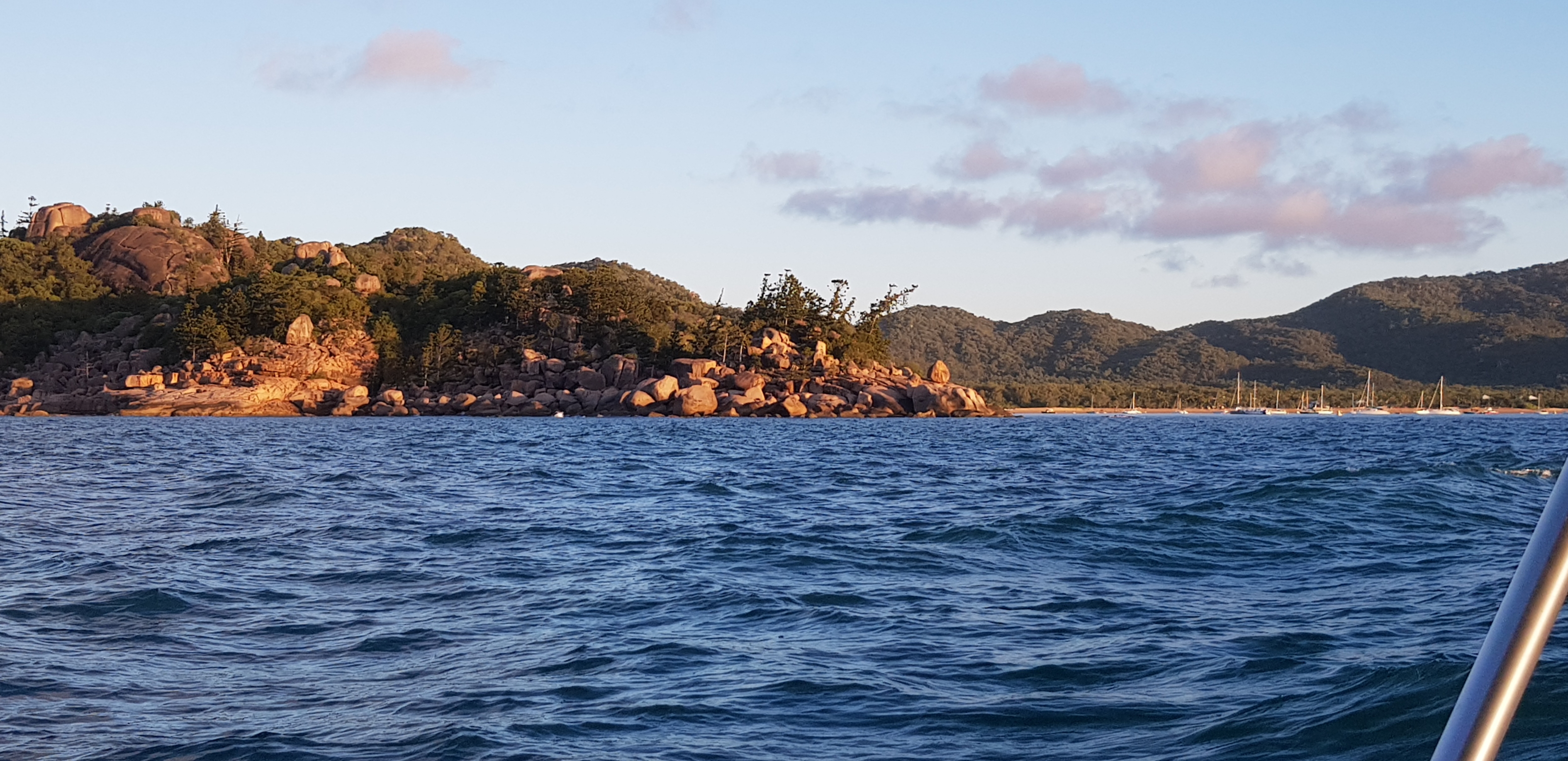
Eva Island, off Cape Sandwich

A light 5 knot SE seabreeze kicked in , so set sail Northwards but was soon motor sailing to keep the speed up and traverse the length of long sweeping beaches with sand dunes. Was able to steer for Eva Islet off Cape Sandwich keeping the motor assisted sails drawing (this reduces revs required and saves fuel)


Decided to take the opportunity and head for Brooke Islands group as the weather was forecast to remain good for the day. These Islands are about 15nm off Cardwell and about halfway to the barrier reef. Way out in exposed waters territory.

Brooke Islands

The Islands formed a beautiful chain of rainforest green humps, laced together with light green coral reef and surrounded by azure blue waters. A magical place that had to be sailed along, slowly ghosting at about 1 knot. Birds were happily living there in the National Park and a marine National park is over the entire area too. One of natures' gems protected.

South of Brooks, a few "reef boats" zoomed by about half mile off, returning from a mornings fishing or diving trip. These are usually about 5-8m long with powerful outboards or inboard engines which can get them out there quickly during the calm mornings and run back downwind when the breeze kicks up (They cost about 3-10 times more than Teria and consume that much more fuel too, but are made for well-funded no-nonsense boaters with limited time afloat. 


Brooke Islands

Teria ghosted along the lee side of the group, slowly passing a barnacle encrusted floating object - a lost divers' flipper, floating for months in the ocean.. Stayed outside pyramid shaped bouys which marked the no anchoring zones near the fringing reefs and anchored for late lunch off a sand cay beach on the Northern end of the small archipelago.

It would have been an amazing place to snorkel, but being solo it was too risky. Only an activity to be done in a buddy system with someone able to operate the boat onboard. (so minimum 3 person crew).

The VHF radio now picked up the crackle of Cairns marine rescue as well as those of Cardwell and Townsville. It was geographically between Townsville and Cairns. At least help if needed was within radio range in all directions here (and no need to last resort of the EPIRB)

The Offshore Islands from this point north are quite different from the ones to the south. These Islands have beautiful dense rain-forest cover, while the southern ones are often windswept scrubby rocks. To the north i could see the Barnard Islands and Dunk Island in the distance. Westward behind Hinchinbrook the Cardwell ranges cloaked in rainforest stretched northwards toward Tully and Innisfail. This area is its own cruising ground with Cardwell as the base ramp.

Beach at Brooke Islands

Hand-steering for long distances like this sure makes an old fella tired, so a good feed, re-hydrate a good recovery nap did wonders. It also brings thoughts of auto-pilots to mind. (like the Raymarine ST1000 tiler pilot..) For now a tiller-brake and remote steering ropes will do. These ropes allow me to sit in the hatchway under the shady bimini/ pop-top and steer from there when motoring.

A bit of afternoon sea-breeze came up about 3pm. So set sail for Gould Island, but with time running out , changed course for the closer Cape Richards. Approached this an hour or so later, running downwind on a broad reach.

Cape Richards

The Cape was the last bastion of permanent human habitation on Hinchinbrook. A classy resort once hid away among the forest overlooking a perfect beach, and it used to welcome yachties at the beach bar in the 1980's Alan Lucas reports in my old CCC. But it is no more today. Nature and economics won out. A cyclone decimated it, and much later a bush fire sadly destroyed what remained of the abandoned ruins. 

Sailed on to the first sheltered embayment near the Cape. Green sea-turtles surrounded Teria, it must have been their sea-grass feeding ground and have never seen so many in one place before! The area looked a potentially exposed to a bit of wave action, so motored a mile or so further along to a National park camp ground on the west shore of Missionary bay. 

National Park anchorage, Missionary Bay

Rounding the final headland there, smoke from a family's beach side fire indicated the first people on shore since Zoe Bay. The sheer scale of Missionary bay was mind blowing. A postcard over water sunset followed by a dome of stars later were other highlights.

Missionary Bay sunset


The other good thing was mobile phone reception returned here. The phone and internet signal had been cut off  since somewhere off Lucinda. So it was nice to catch up with family again and switch the star identifying app, 

The ice in the esky was all melted by now, so ate the last fresh fruit. Started on the dehydated and tinned foods. (the precooked meals lasted first 2 days on ice)


Hinchinbrook Island cruise - Dungeness to Zoe Bay (Day 2)

 Fri 25 Sept 2020.

To comfortably cruise the East Coast of Hinchinbrook in a small boat requires a good weather window. Even before leaving Townsville, the long range weather forecast was watched carefully..on apps like Seabreeze, Willy weather wind. Mostly for the forecast wind and sea heights, also the Bureau of Meteorology (BOM) for synoptic charts which show the isobars and pressure systems affecting wind strengths. September is still middle of the northern dry season so rain was unlikely. Generally SE to NE seabreezes blow most days at 15-20 knots, with winds easing off at night. but passing high pressure systems down south can weaken the winds for a few days.

The wind was forecast light with slight sea for a few days, so decided to visit the east coast first up and hopefully reach the more sheltered waterways off the north coast and Channel before conditions piped up again. Even if daily seabreezes kicked in early they would generally help north bound sailing. but the main problem is finding a calm enough anchorage and not being blown onto a lee shore.

Departed Dungeness early and headed into flat calm conditions under motor. Followed the red nav bouys and fishermen's boats out, then turned and headed past the sugar sheds at 5 knots and followed the 6 km long sugar loading jetty out (as shoal waters closer to the Island) 

Departing Dungeness for Hinchinbrook Island

The channel out of Dungeness

Lucinda sugar sheds, Molasses wharf shed on right

Lucinda sugar jetty

Large Catamaran and powerboat overtake

Lucinda bulk sugar loading terminal, 6 km from land

Set course for Zoe Bay once the shallows were cleared, still flat calm. Had the main up in case any wind came and for awhile a light SW land breeze pushed Teria along silently at 3 knots. The wind shadow of the Island soon had the motor going all the way into Zoe bay.

These videos show the contrast between motoring and sailing. Noisy but fast/reliable vs slow but peaceful.


Anchored off the South Zoe creek entrance and National Park camping ground. Closer than the few cruising catamarans and other yachts.

Took the kayak in and pulled up in the creek near about 4 power boats. Chatted with a bloke in a substantial sized camp, then walked about 1 km through rainforest up to Zoe falls base pool. Then up a steep hillside to the top pools of the falls for great views. A hiking group was up there and had a chat or two, most people like to know where you originated from and how you got there. Solo sailing an 18 fter probably an unusual story. They were on a 5-day trek of the Thonsborne trail, there were quite a few fit middle aged there, so it's not just for the young only. (other groups may have arrived by boat)

Zoe Bay vista

South Zoe falls

Zoe Bay from top of falls lookout

South Zoe creek, camp ground landing

Zoe Bay beach

Motored across the Bay past about 5-6 cruising vessels 30-50 footers, mostly catamarans and one mono hull. The mountain to beach scenery is spectacular, world class. Dropped anchor off North Zoe creek, applied the insect repellent, then explored it with the kayak. It's alot larger than the other creek, with a reasonable tidal entrance for shoal draft boats (has a few scattered coral rocks) bit soon drops into some deep pools among mangroves. 

Met a couple on a Northwind 7 trailer sailer, their boat nestled against the beach. (It's shallower draft than an Investigator, but is a much larger boat at 22 ft loa) they were well prepared for creek anchoring with a pop-top sandfly net (from Canada) and a 12v fan below. Definitely experienced TS cruisers. Their route was similar to my one, anti clockwise out of Dungeness, as the prevailing winds are favorable on the east side and easy to get back against the wind in the sheltered channel. 

Saw a 40 ft Wharram cat anchored further up the creek. A crazy speed boat came out at planning speeds, although the wake was fine in the kayak, it messed with the Northwind TS nosed in on the beach a fair bit with the skipper holding it off while the wake hit them. 

Decided to stay anchored out away from the sandflies. Found the old mosquito net up in the forward locker and draped it over the pop-top. Also lit a mosquito coil in the cabin as usually done and had no problems with the biting insects. 


Mt Bowen, Zoe Bay

North Zoe creek

Regarding boat wakes in anchorages, I've found that the Investigator 563 seems to handle them fairly well and nothing has fallen over dangerously onboard yet (even the lit up Trangia stove, touch wood). Maybe its the permanently low center of gravity of the lead keel of an I 563?